Locations
The instrumentation of the DACAPO-PESO field experiment will be deployed at 3 different sites.
1) Location of the Measurement site of LACROS
The main site of the LACROS measurement containers is located at:
53.1346°S, 70.8834°W, 9 m a.s.l
2) Location of radiation measurements
The roof platform of LIA/UMAG provides full-hemispheric view and thus perfect measurement conditions for radiation sensors. It is located at:
53.1354°S, 70.8845°W, 25 m a.s.l
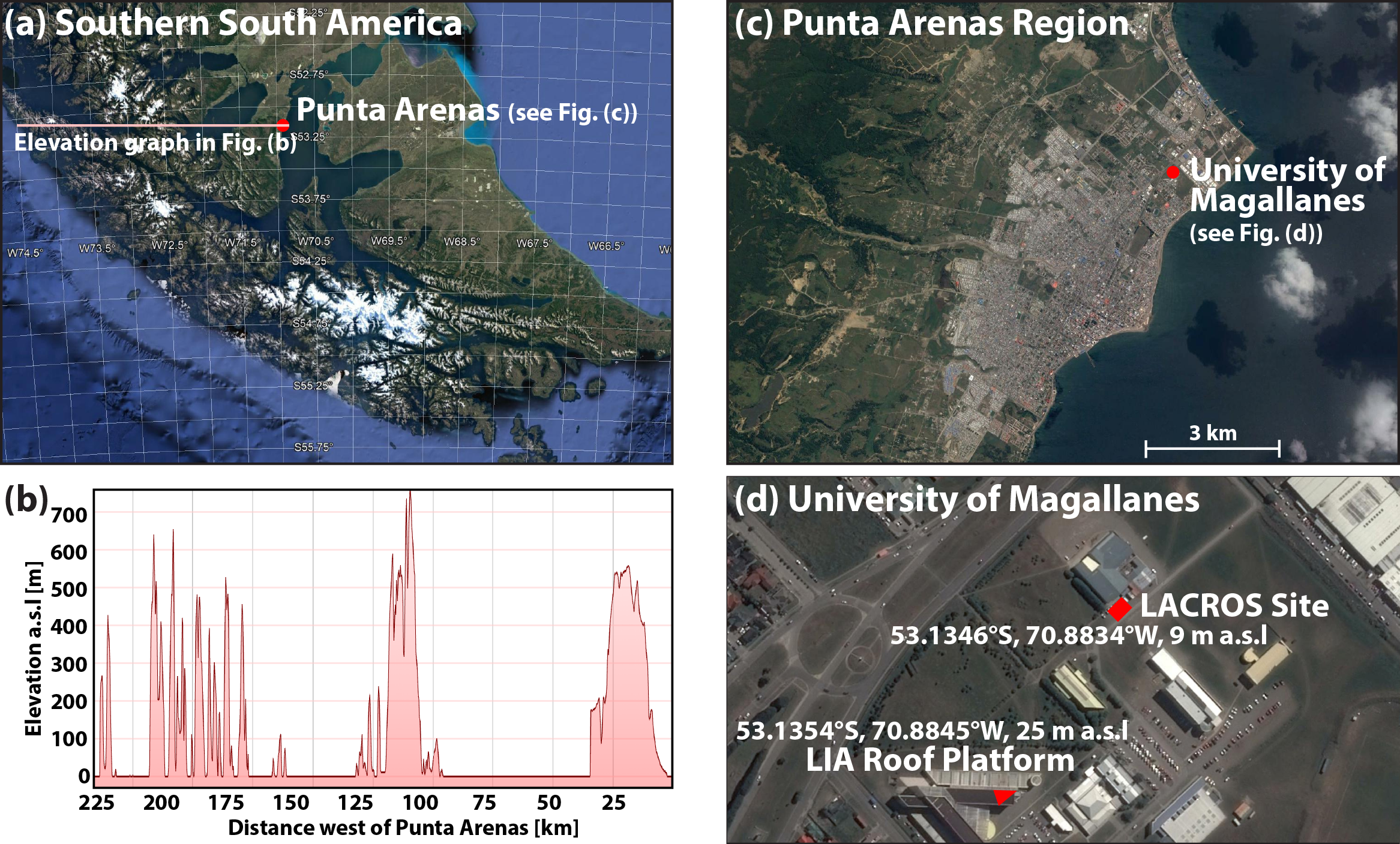
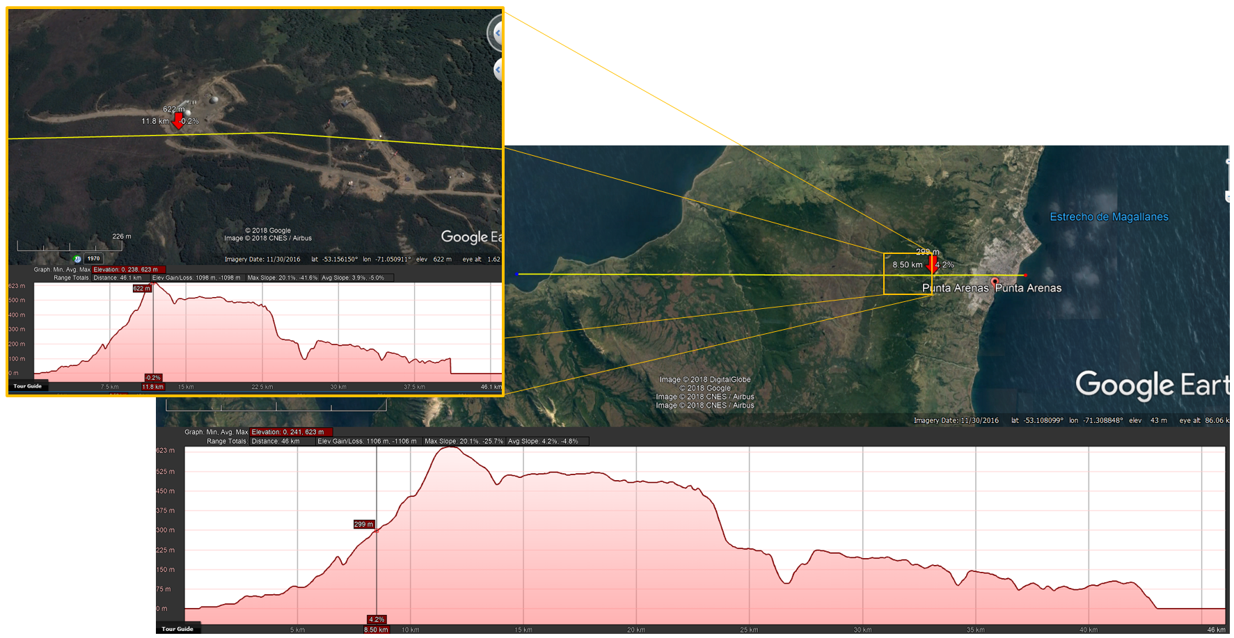
3) Aerosol in-situ observations (planned for Jan 2019 - Dec 2019)
It is planned to install aerosol in-situ measurements at the top of the 622-m high mountain Cerro Mirador 8 km west of Punta Arenas. There, observations of aerosol number size distribution, cloud condensation, nuclei number concentration, and filter measurements of ice nucleating particle concentrations will be performed. The coordinates are:
53.1561°S, 71.0509°W, 622 m a.s.l.
DACAPO-PESO
The project Dynamics, Aerosol, Cloud and Precipitation Observations in the Pristine Environment of the Southern Ocean (DACAPO-PESO) is motivated by need to provide an explanation for the observed evidence of strong regional contrasts in heterogeneous ice formation efficiency. Various studies report that heterogeneous ice formation in the temperature range between -40 and 0°C is more efficient in the northern hemisphere than in the southern hemisphere. This conclusion was also supported by lidar observations of stratiform clouds in the northern midlatitudes (Leipzig, Germany, 51°C) and the southern midlatitudes (Punta Arenas, Chile, 53.1° S) which were conducted by Leibniz Institute for Tropospheric Research (TROPOS), Leipzig, Germany.
Meanwhile, the mobile ground-based supersite LACROS of TROPOS is operated to provide observations with co-located lidar, cloud radar, precipitation-profiling radar, Doppler lidar, microwave radiometer, sun photometer, precipitation disdrometer, a radiation balance station, an all-sky cloud camera and irregular launches of radiosondes. These observations allow to derive aerosol-cloud-dynamics-precipitation interaction in much higher detail than with lidar alone.
In Europe LACROS has collected multi-year datasets of these observations for the continental site of Leipzig and the strongly mineral-dust-burden subtropical region of Cyprus. In a next step, LACROS will be deployed in Punta Arenas, Chile, which is the southernmost point of continental land mass of the southern hemisphere showing a mitlatidudinal to subpolar climate. Contrasting the LACROS observations from Leipzig, Cyprus, and Punta Arenas, which are based on the same instrumentation, will allow to infer the reasons for the regional observed differences in heterogeneous ice formation efficiency.
Target Area Map
These are the areas connected to the DACAPO project. Click on them to see further information.